It’s not exactly “hands-free” driving, but operators of the bulldozers and other heavy equipment developing the Summit Bechtel Reserve have a co-pilot high in the sky.
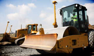
Hulking, 50-ton machines such as the D9 Caterpillar are being precision-guided to within inches of blueprint plans on the Summit grounds with the help of global positioning technology (GPS). The digital guidance, mounted on each machine as it smooths out campsites or shores up a hillside embankment, communicates with satellites orbiting above.
“Without that technology, we wouldn’t be able to move at this pace of construction,” said Mike Patrick, general manager of the Summit.

To get infrastructure and facilities in place in time for the 2013 jamboree, construction crews have regularly worked 2 shifts a day, 6 days a week at times since development began last July. Patrick said the precision enabled by the GPS technology has kept progress advancing rapidly.
“It would have taken a year just to plant all the flags you need to guide these machines without the GPS,” Patrick said. “People would have had to walk the entire site, planting those flags by hand to guide the equipment and operators.”
The GPS-enabled excavation work also means that the machines can work at night, which speeds up the pace and reduces the number of surveyors needed on the project.
The engineering professionals at Trinity Works, the developer of the Summit, said the GPS (or surveying and flagging) is essential to account for discrepancies in mapping data. United States Geologic Survey maps, for example, provide good topographical information, but only at a “rough” scale. Different maps for different purposes are often made using different projections, or mathematical ways of interpreting map data; they don’t always “line up” perfectly when combined.[pullquote] “It would have taken a year just to plant all the flags you need to guide these machines without the GPS.” — Mike Patrick, general manager of the Summit[/pullquote]
Down on the ground, where moving an inch off-target means significant consequences, architects and engineers often have to develop their own, more precise map information. This coordinate information — often handled by geographic information systems (GIS) experts — is what construction crews rely on.
“So as that bulldozer or grader operator is driving, they’re checking a computer screen that’s receiving that satellite information and telling the machine, OK, raise the blade a bit here, now lower it back down,” said Allison Schapker, Trinity Works director of sustainability. “The operators are still driving, but they’re getting a lot of digital help.”
How do you use GPS equipment in Scouting? Have you ever used GIS data and applications to make a map?


